
Rifugio Giussani rises in the middle of Forcella Fontananegra at 2561 mt, a wide pass between Tofana di Rozes and Tofana di Mezzo, among huge boulders and WWI firing points. The entire area offers the chance to discover a part of the Dolomites, where a very sad page of Italian history during World War One was written.
All around this side of the mountain it is possible to visit old war buildings and surpluses. The suffering, hardship, and death those very young soldiers endured becomes painfully clear.
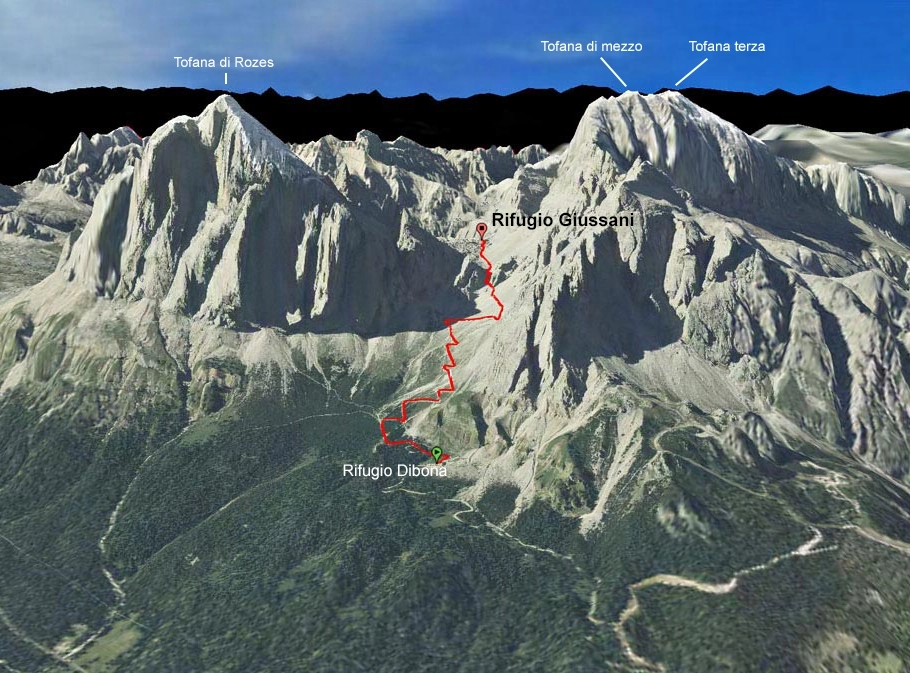
Usually you can drive up the main regional road (sr 48 of the Dolomites) from Cortina to the Refuge Angelo Dibona (2083 mt), situated in Valon the Tofana, at the base of the south wall of Tofana di Rozes. From the Rifugio Dibona, take a pebble track up to a gravel funnel enclosed between the Tofana di Rozes and Punta Anna Massiffs. Next you can follow the mule track n. 403. Ascent time ca 1,30 hrs.
Another way is from Rifugio Duca d’Aosta (2098mt) and Rifugio Pomeds (2303 mt) along the via ferrata M.L. Astaldi. Just below the Pomedes Hut starts the Astaldi trail, it develops through multicolored rocks and along a ledge at the bottom of Punta Anna and Torrione Dibona (Dibona Tower) (fixed metal ropes) aiming for a grassy rise edging the Valon and connecting with the above itinerary.
Ascent time from Pomedes: 1,30 hrs.
An interesting option begins at Fiames (4 km north of Cortina) entering The Dolomites National Park (ample parking on site) and hikes up the scenographic Val Travenanzes and the Majariè of Tofana. It is a path of medium difficulty level.
Ascent time: 4,30 – 5 hrs.
A variation to this itinerary is the “Scala del Minighel” Route (see Excursions and Via Ferrata).
There are of course many alternatives to reach the Giussani, for which the reader is referred to the specialized bibliography.
Cartography: Tobacco Topographic Map – Scale 1:25.000 nr 03 – Cortina d’Ampezzo e Dolomiti Ampezzane
| Cookie | Duration | Description |
|---|---|---|
| aka_debug | session | Vimeo sets this cookie which is essential for the website to play video functionality. |
| player | 1 year | Vimeo uses this cookie to save the user's preferences when playing embedded videos from Vimeo. |
| Cookie | Duration | Description |
|---|---|---|
| sync_active | never | This cookie is set by Vimeo and contains data on the visitor's video-content preferences, so that the website remembers parameters such as preferred volume or video quality. |
| Cookie | Duration | Description |
|---|---|---|
| vuid | 2 years | Vimeo installs this cookie to collect tracking information by setting a unique ID to embed videos to the website. |
| Cookie | Duration | Description |
|---|---|---|
| wp-wpml_current_language | session | This cookie is used by the WordPress WPML plugin and is used to remember the language code of the last page visited. |